1/8


Gps Area Calculator
23K+下载次数
33.5MB大小
41.0(24-04-2025)最新版本

详情评价版本信息
1/8
Gps Area Calculator介绍
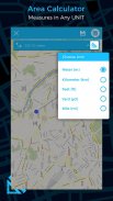
字段区域测量是用于测量地图上区域的智能工具。将点放在地图上然后计算所有点之间的区域。你也可以计算蚂蚁路线的总面积。
场区域测量可用于精确计算GPS区域或GPS距离。有两种方法可以测量任何GPS区域或距离
新添加的兴趣点或POI,此应用程序用于保存和共享某人可能觉得有用或有趣的特定点位置。
特征:
- 快速区域/距离映射。
- 智能标记模式,可实现超精确的引脚布局。
- 测量保存和编辑
- 测量单位改变设施。
- 地图,卫星,地形和混合模式
- 区域搜索设施。
GEO AREA适用于:
- 陆上调查
- 农民,农场管理
- 土地记录管理
- 施工调查
- 农学家
- 城市规划师
- 施工测量师
- 健康,教育和设施制图
- 农场围栏
- 运动跑道测量
- 建筑工地和建筑工地区域
- 资产映射
- 风景画家
- 景观设计
添加新的GPS工具如下
- GPS指南针
- GPS车速表
- 位置保存和共享

Gps Area Calculator - APK信息
APK版本: 41.0程序包: kbk.maparea.measure.geo名称: Gps Area Calculator大小: 33.5 MB下载次数: 1.5K版本: 41.0发布日期: 2025-04-24 17:38:34最小屏幕: SMALL支持的CPU: x86, x86-64, armeabi-v7a, arm64-v8a
程序包ID: kbk.maparea.measure.geoSHA1签名: E9:37:FB:A0:33:66:6C:8D:E4:E1:A8:F2:0C:2A:F6:48:D0:9F:9C:6E开发商 (CN): applockth组织 (O): 本地 (L): 国家/地区 (C): 州/市 (ST): 程序包ID: kbk.maparea.measure.geoSHA1签名: E9:37:FB:A0:33:66:6C:8D:E4:E1:A8:F2:0C:2A:F6:48:D0:9F:9C:6E开发商 (CN): applockth组织 (O): 本地 (L): 国家/地区 (C): 州/市 (ST):
Gps Area Calculator的最新版本
41.0
24/4/20251.5K 下载次数33.5 MB 大小
其他版本
40.0
8/2/20251.5K 下载次数33.5 MB 大小
38.0
5/2/20251.5K 下载次数33.5 MB 大小
37.0
4/2/20251.5K 下载次数33.5 MB 大小
21.0
22/3/20221.5K 下载次数16.5 MB 大小
13.0
24/6/20201.5K 下载次数8 MB 大小
1.2
4/1/20171.5K 下载次数4.5 MB 大小


同类应用


English


